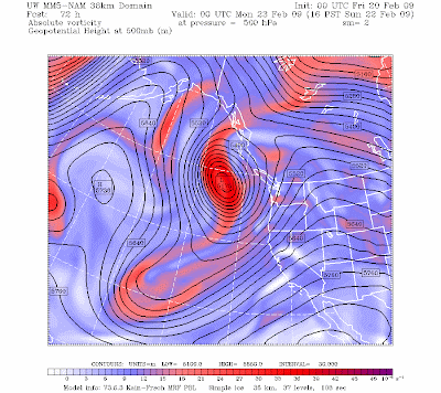

I often warn about taking long-range forecasts (beyond 5 days) too seriously...particularly when we talk about snow. Today is a good example where even 3 day forecasts are very, very uncertain. Attached are the 500 mb upper level charts for 3 days out...from the National Weather Service GFS and NAM models (the top two models used by my colleagues in the NWS). They are radically different--much more so than we usually see. What does that tell us...very substantial uncertainty. If 3 days out is uncertain, what do you think is the case for the 7-10 snow events some are talking about? The GFS model usually is the best...but this is the kind of situation that really reduces my confidence.
Meteorologists have a powerful tool fo
 r assessing uncertainty ...ensembles collections of many model runs. We run an ensemble system at the UW and it shows major differences between the solutions from modeling centers around the world. Attached is a graphic showing the differences in 500 mb heights (think of it as pressure in the middle troposphere). The yellow and brown colors indicate very major differences in the 72 hr forecasts of the ensemble members...indicating large uncertainty. It can be intoxicating to view the long-range forecasts and think about what they imply. But you need to understand the uncertainty that exists. Furthermore, the uncertainty varies by situation--and understanding that uncertainty and how to estimate it is the difference between my skilled colleagues in the NWS and people who simply look at the model output.
PS: Will be signing books at the garden show in seattle at noon on Sunday...
Tidak ada komentar:
Posting Komentar