 This morning there was considerable black ice as the wet roadways froze after the skies cleared.
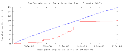
Most of the Puget Sound lowlands and the Cascades have been in a virtual drought the past month, as most of you are are. The precipitation trace at Sea-Tac shows the story (see image). The precipitation of the last day didn't change the story much...except for locations like Shelton near the SE side of the Olympics. The snowpack is rapidly declining to well below normal...and this is a La Nina year when snowpacks are typically above normal! But what is really disturbing for weather lovers is the latest long range weather model forecasts that show the dry conditions continuing for the next week. The West Coast is stuck in a major large-scale trough, with the jet stream and most of the weather going into Oregon and California (image). We are generally left high and dry. But this is all very good news for a drought-stricken California.

Very little new snow in the Washington Cascades for the next week. The snowpack, which generally peaks around March 15, has time to recover, assuming the pattern changes, but winter in the lowlands has only about another week or so to run. Typically, the chance of major storms and floods declines rapidly after the third week of the month.
The good side...lots of sun today.
Tidak ada komentar:
Posting Komentar