The truth is that all forecasts are uncertain. That uncertainty increases in time. The amount of uncertainty varies by weather situation. Sometimes even a 3-4 day forecast is highly uncertain (like yesterday),while other times there is substantial forecast skill out 7-8 days. The fact that TV stations (and even the NWS) usually give single numbers for forecasts...particularly long-range ones is really crazy...we just don't have that kind of precision and skill. Forecasts are essentially probabilistic...and should be communicated that way. We should not forecast the temperature will be 64 in three days, but rather give the probabilities of various ranges.
This is a very active area of research and development right now...and the key tools are ensembles of forecasts. The old way is to run one computer simulation of the future and use that to provide a single potential weather evolution and single forecast numbers. Now we have much more computer power we can run many forecasts, each with a slightly different (but reasonable) starting condition or with somewhat different model physics (e.g., how clouds form). The forecasts will be different and the differences will generally increase in time. When the forecasts are very similar...then uncertainty is low, and vice versa. You can get probabilities from them as well. If half the simulations give rain and the rest do not...then a 50% chance of rain is reasonable (we have much more sophisticated ways of doing this, but it will serve as an example).
The NWS has several ensemble systems, as do we at the UW.
They are actively used to determine how uncertain the forecasts are and to understand the range of possibilities. We are now trying to develop the techniques to provide high-quality uncertainty/probabilistic information from the ensembles. In five years we should have reliable forecasts of this kind. But then there is the next problem....how do we communicate the information? Are people ready for such guidance? Are you ready for it?
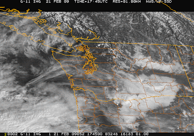
Regarding today's forecast...lots of low clouds in eastern WA, but generaly sunny elsewhere. High clouds are moving in overhead as a system approaches from from the SW (see images). Tomorrow we will have considerable clouds and showers. And that will be the character of the upcoming week...with the mountains finally getting a modest amount of snow (particularly midweek). From my viewing of
 the ensembles, there appears to be very little likelihood of lowland snow...one of the reasons I was discouraging such talk from those looking at long-term forecasts.
I will be at the NW Flower and Garden Show in Seattle tomorrow at noon if anyone want to talk in person. And don't forget the KIRO weather special at 7 PM on Monday...it should be good.

Tidak ada komentar:
Posting Komentar