Senin, 28 September 2009


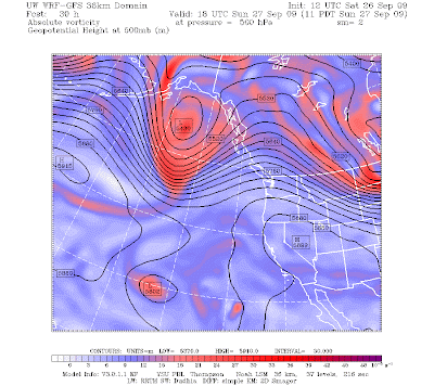
The front made it in late this afternoon and early evening as shown by the infrared satellite photo above. Winds really increased this afternoon as the front approached as winds reached 20-25 mph in places. If you look carefully, you will see the mottled cloud pattern over the ocean...those are the classic postfrontal instability showers produced by cooler air aloft over warmer water. You will notice an area of enhanced showers out there...that is associated with an upper level trough (see map for 500 mb, the lines give the height of this pressure above sea level). So expect showers and sunbreaks tomorrow.

The latest radar image shows the frontal precipitation on the east side of the sound and an area of enhanced showers from Sequim to Whidbey Island...this is from a convergence zone to lee of the Olympics...since winds are now from the SW aloft. All convergence zones are not over Puget Sound! It all depends on the wind direction.

Sabtu, 26 September 2009

Nice Weekend and then Downhill a bit


I returned on Friday from a workshop in Boulder, Colorado on developing the next generation weather prediction system. Such a system would be essentially probabilistic in nature---rather than giving a single answer as we do today. It really doesn't make sense to say the high temp at Seattle in seven days will be 67F--there is substantial uncertainty in the answer and that uncertainty depends on the situation. My field is developing the technologies to provide uncertainty information--including probabilities of much more than precipitation. This is a major revolution in the way we do business. But is the population ready for this? Will they accept and use it?

While I was in Boulder it snowed! On Wednesday, there were snow flakes in the air, with temperatures dropping into the upper 30sF. Being over 5000 ft and open to the cold air to the north really helps.


This weekend will be moderate in temperature and very nice here in the NW. Look at the latest satellite image (above). You will notice some residual low clouds from a dissipating front that moved through this morning. But skies will clear and temps should rise into the mid and upper 60s for most of the west.

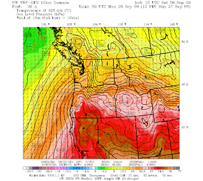
Tomorrow will be even nicer. High pressure (ridging) will develop aloft and its surface manifestation will be high pressure to our east (figure). You know what that implies...offshore flow and compressional warming as air descends the western slopes of the Cascades (see figure). Our friend the thermal trough will be back. So tomorrow will be sunny with many temps rising into the upper 60s and lower 70s.

Monday really won't be too bad. A week front will approach...but will not arrive until late in the day. Thus, most of Monday will be dry, but with increasing clouds and chance of showers very late in the day.

Tuesday should be cooler and showery...but really nothing to write home about.

So enjoy a very nice weekend....

Selasa, 22 September 2009

Big Daily Temperature Range and Foothills Heat


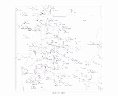
Today was hot, with many locations getting into the mid and upper 80s, and some foothills locations reaching into the 90s (see map of temps and winds at 5 PM). Why the foothills? The reason is we had fairly strong easterly flow today with downslope flow and compressional warming of the air descending the slopes. (see Seattle profiler winds and temps to see the easterly flow and warming aloft). North Bend is a favorite place for hot temps on such days because it is at the base of the Cascades and gets the maximum downslope heating. Hint: during the late fall it is sometimes MUCH warmer near North Bend and the foothills than anywhere else--good place for a hike or bike ride!

Last night there was good radiational cooling to space (since we had clear skies) and temperatures fell over most of the region...but near the foothills the temps really held up due to the downslope. See for yourself with the weather map at 7 AM. Over 70F in the foothills...but in the 50s and 40s elsewhere!
Another interesting aspect of temps today have been the large diurnal (daily) temperature range...something we frequently see in the fall under these conditions. With full sun and downslope offshore flow the temperatures can still get quite warm during the day, but the nights are getting much longer now (unfortunately for my tomatoes), and with clear skies there is good radiational cooling to space. Today, many locations were in the 40s this morning and skyrocketed to near 90F....nearly a 50F change over roughly six hours. That will crack some concrete! Don't believe me? Take a look at the temps at Shelton today (graph), where the temperature climbed from 41 to 89 over a few hours!
Tomorrow (Wed) will be slightly cooler and a marine push will occur tomorrow night....ending the heat wave. But no major weather in sight.

Minggu, 20 September 2009

Super-Ridge and Late September Heat Wave


Last week I was in California...dropping my son off at college and visiting Yosemite Park. It was hot down there...even reaching 90F in the Yosemite Valley, but that is nothing compared to what is going to happen during the next few days--both down there and up here in the NW.

Take a look at the temperatures of the past two weeks (see figure above). In general, the high temps have been at or above normal...and the minimum temperature much above normal. But real heat is about to turn on.

A huge, high-amplitude upper ridge is developing over the west coast (see forecast for Tuesday morning). This is really amazing...with unusually high pressure developing aloft and at low levels. Such a major ridge is associated with warm temps aloft and with offshore flow and added warming at low levels. Look at the computer forecast for Tuesday (see figure). Very, very warm temps in California, offshore and downslope flow over the Cascades, warming over our region. Notice the development of the "thermal" trough into western Oregon and Washington....the classic warm weather pattern.
Western Washington should surge into the mid-70s tomorrow and mid-80s on Wednesday and Thursday. Impressive for late September! And I have no plans to return to California where temperatures of purgatory will abound. A heat warning is up for the SF Bay Area where some interior locations will get well into the 100s. Yosemite Valley will be in the mid 90s.
And don't forget the Willamette Valley...where temperatures will climb into the 90s. The Willamette is often 5-10F warmer than the western Washington interior...frequently even warmer.

Senin, 14 September 2009

Should you take a chance on a season ski pass this winter?

Do you feel lucky?

Several of you have asked about the outlook for this coming winter...and specifically what it implies for the ski season. Should you buy that season pass at Snoqualmie Summit or Stevens?

I hesitate to answer this question...I am already in big enough trouble with KING-5 for teasing them about my favorite Jim Forman....I don't want the Washington State Ski Owners Association on my case. So I won't give you a specific recommendation. Just some information.

This is going to be an El Nino year...one in which the tropical Pacific is warmer than normal. Take a look at the latest data over the Pacific (see attached). Meteorologists pay particular attention to the Nino3.4 area, and you can see it and adjacent sections of the tropic Pacific are now well above normal and are predicted to warm further this winter.

During El Nino winters the Northwest tends to be warmer than normal and a bit drier than normal (see figures). Cascade snowpack tends to be less. Remember this is a statistical relationship. There is a correlation with less snow during El Nino years in our mountains and in the lowlands. We will probably see less snow than last year (which ended up a surprise La Nina year). The Seattle Dept of Transportation will have an easier year, pretty much for sure.

Should you get that season ski pass? To quote Clint Eastwood: "Do you feel lucky?"


Minggu, 13 September 2009

The Marine Air Cometh

6 PM visible satellite image
It has been a perfect weekend. I even finished painting my deck--ready for the storms of winter! But something is happening on the western side of the Cascades...the marine air is moving in. Notice the increase in wind speed? Or the change in wind direction? My wind chimes are ringing and the cool breezes are extraordinarily pleasant. Both the Huskies and Seahawks won this weekend, and all is right with the world.

There was a distinct contrast today in sky conditions--with a band of clouds along the Washington and Oregon coasts that extended southwestward over Oregon. (see satellite pic above). Even some light rain showers on the coast. An upper trough aloft has been slowly approaching and this afternoon its influence initiated the push of marine air eastward. Take a look at the surface chart this afternoon--southwest winds pushing into Puget Sound...with some winds gusting to 15-20 kts. In the Strait of Juan de Fuca, westerlies are moving eastward. The result..tomorrow will be cooler and cloudier--particularly in the morning--with some sunbreaks in the afternoon. Well, at least it will make it easier to go to work.

The weather observations at the UW (shown below) indicate that the temperature is about ten degrees cooler than yesterday at the same time. You can see the switch to southwesterlies around 11 AM (18Z) and the steady rise in pressure as cool, dense air moves in. And the winds!

There have been a number of comments to the blog about El Nino..and I will talk it about it more this week... but keep in mind that El Nino has little impact on our summer or early fall weather--so you CAN'T blame this wonderful September weather on the tropical Pacific so easily! And a number of you want some guidance on purchasing that season pass at Snoqualmie Pass or some other ski area. More on that later! So hold off for a few days.

Jumat, 11 September 2009

Extraordinary Weekend

The red straight line is the average max, blue the average min

The past few weeks have brought temperatures at or below normal over western Washington, and above normal precipitation (see graph of temperature). This has radically reduced the fire danger threat over the west and knocked it way back east of the Cascades. But today and tomorrow summer will be back, REALLY back.

Warmer air has moved over our region and offshore flow...the key for heat in western Washington and Oregon..has returned. Don't believe that?--look at the winds aloft from the Seattle profiler this morning (see graphic). It is going to burn today, with many places away from the water getting into the upper 80s. Some places will break their daily records.

Probcast..the UW prediction website..which is almost perfect in such warming events is going upper 80s! Try it out yourself at http://www.probcast.com/ See graphic from it below.


A nice evening to enjoy a stroll in a park. Or enjoy a tropical drink on the deck.


Tomorrow will be equally as good (warm). Full sun. Sunday will be a step down into the 70s...but still very nice. And nothing threatening on Monday and Tuesday.

Perfect painting weather...which is what I will be doing. Unfortunately.

Selasa, 08 September 2009

The Enumclaw Tornado

Picture courtesy of KOMO TV

Enumclaw means "place of evil spirits" in the native American vernacular and it lived up to its name on Sunday: a tornado, which started around Bonney Lake moved eastward until weakening over the the town. According to an excellent report by the National Weather Service this was a confirmed category 1 storm with winds reaching 100-110 mph. The funnel hit the ground around 4:15 PM on Sunday and continued for 9.6 miles and 16 minutes. A barn and silo was lost, some greenhouses damaged, and lots of tree damage.

The news outlets have been hitting this real hard (for once they didn't have to hype the storm...this was the real thing!).

Tornadoes are rare around here, because they generally form from supercell storms and squall lines...intense thunderstorm features that we infrequently get around here. Why don't we get powerful thunderstorms? The cool waters of the Pacific are to blame. Cool water means a lack of moisture in the air (since warm air contains more moisture than cool air), and cool air near the surface generally works against developing a large change in temperature with height...which convection needs to form (or you require in your saucepan to get convection of your hot cereal).
On Sunday the air was quite unstable for around here, with relatively mild temps near the surface and cold air moving in aloft. And the convection was initiated by an upper level feature moving in aloft. And your remember the resulting lines of convection--with some embedded thunderstorms--that pounded the whole area that day. One of those thunderstorms produced that tornado. In my book I talk in depth about how these non-supercell tornadoes form, so I won't go into too much detail here. But they generally form near some kind of shear line at low levels, where wind changes direction substantially with distance.
Anyway, the first thing I did was to look at the visible satellite picture and weather radar to see if I could spot the storm...and I have attached what I found. Hard to see the storm on the visible image unless your really knew what you were looking for, but in the radar you can see it clearly...that area of green and yellow southeast of Tacoma. Can you spot it? A problem is that Enumclaw is a good distance from the radar (which is on Camano Island).

Next I looked at the Doppler velocity of the radar, which you never see on TV. Ironically, they NEVER show the Doppler part of the Doppler radars! (Funny story...when KING-5 got their own Doppler radar, they showed the velocities for a few days...that didn't last long. It is really hard to interpret Doppler images).

Below is an example of the Doppler velocities with the overall wind removed (storm-relative velocity). You can sometimes see rotation by a sharp reveral of color in a small area (the signature of the mesocyclone associated with the tornado). There is a hint of a feature (the small yellow dot with the green next to it in around the right place) that was there for several scans...but it hard to know whether that really signified anything. Looking at this image you can see why they don't show Doppler radar images on TV!

Sabtu, 05 September 2009

Forecast Error?


Sometimes forecasts go wrong and sometimes the communication of details is inadequate...and today is a mixture of the two.

Significant showers are mostly over for the western lowlands and bright sun is now features over the San Juans and even a sliver down Puget Sound. (see satellite image). There is almost nothing immediately offshore. And the radar shows the rain mainly over the mountains now.

Forecast failure? Well, not exactly. The computer models yesterday showed a wet frontal system coming in this morning and that it would move through mid-afternoon, resulting in showers and sun breaks late in the day..and in fact the 3:30 AM NWS forecast tells this story:

330 AM PDT SAT SEP 5 2009
TODAY...RAIN AT TIMES THROUGH MID AFTERNOON. THEN MOSTLY CLOUDY WITH A CHANCE OF SHOWERS LATE IN THE AFTERNOON. HIGHS IN THE 60S. SOUTH WIND 5 TO 15 MPH.

However, there was a timing error...and the frontal moved through roughly 3-4 hours earlier than predicted. The result is that we have gotten into the post-frontal situation early...with sun breaks and only a few showers. The southern San Juans are in bright sunshine now and sun is blazing here in Seattle. But not for long. There is often enhanced clearing right behind the front, with some showers/clouds behind that clearing...and you will notice another band to our west. So don't expect a clear day--some of this cloudiness will move in during the next few hours. But the serious rain is over, sunbreaks will occur today, and I am heading outside to pressure wash part of my house in preparation for some painting. The NWS has even modified their forecast:

1030 AM PDT SAT SEP 5 2009

REST OF TODAY...SUN BREAKS AND SCATTERED SHOWERS. HIGHS IN THE 60S. SOUTH WIND 10 TO 15 MPH.


The lesson of all this? Timing errors can occur and you can enhance your ability to do things outside by watching the weather carefully. And my profession needs to communicate timing issues better--I suspect most people didn't realize the near certainty of a break this afternoon.

And I hope the new coastal weather radar will fix this kind of timing failure...providing information upstream that would have allowed a corrected forecast last night. I have a graduate student, Reid Wolcott, working on just this issue--developing approaches for using an upstream radar in numerical weather prediction. If his research pans out and the new radar gets installed, weather predictions may get a lot better around here.

Kamis, 03 September 2009

The Weekend of Wet

Cancel your hike on Saturday. Get a good book (hint...a suggestion is on the upper right of this page). Don't water your garden tomorrow. The weekend of wetness is coming. And the end of any serious threat of wildfires over the Northwest.


But not tomorrow. A weak front is approaching right now (see image) and could bring some light rain to the coast, but only some sprinkles will hit over the interior.

But wait until Saturday, when a moderate front..with plenty of moisture... will reach us.
The rain from the front will approach the coast in the early morning hours and the western lowlands between 7 and 9 AM. The three hour rainfall ending 11 AM is shown below. The front will move through during the day, bringing rain to the Cascades and even some showers to the east of the crest. Take a look at the 24-h rainfall ending 5 PM below. Perhaps a 1/4 to 1/2 inch over the lowlands. Not a good day for a hike in the Olympics. You could get away with a hike on the lower eastern Cascade slopes if you go early.
But wait. The fun doesn't stop there. The front moves through Saturday evening, followed by a short break in the action. Then an upper trough moves in bringing more showers to the region on Sunday. Take a look at the precipitation for the 24-h ending 5 PM on Sunday below. Plenty of rain over the entire state..with particularly heavy rain on the SW side of the Olympics...roughly two more inches. And eastern Washington gets enough to wet things down.
And did I mention the winds? A surface low will accompany Sunday's trough...bringing windy conditions over the ocean and along the coast (see graphic). And 25-35 kt southeasterly winds will develop over NW Washington.
Time to find your rain jackets that have been buried in your closet. You will need it. And one more thing...watch the driving. It has been fairly dry and there is lots of oil on the road. Add water and it will be slippery.