A powerful marine push is about to happen. Extraordinary onshore pressure differences have developed as the thermal low has shifted into eastern Washington. Look at the attached pressure differences . The difference between North Bend, Oregon (on the central coast) and Seattle is now 7.5 mb and the Hoquiam is now nearly 6 mb higher than Seattle (8 PM). The latter is HUGE. I forecast a major push when that difference is 4 mb, but 6? Strong wind sand cooling temps have already pushed through Hoquiam, Shelton and Olympia and will enter the Sound during the next few hours. Temps will drop, winds will gust, wind chimes will ring, and a comfortable night of sleep beckons. (I REALLY love these pushes, I have to admit)

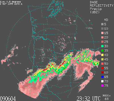
But that is not all!! A very strong line of thunderstorms hit northern Oregon this afternoon and early evening, with hundreds of lightning strikes, and winds gusting to 40 mph and more. Tens of thousands have lost power, trees are down, lots of heavy rain and hail. Take a look at two radar images (4:32 and and 7:24 PM) the line of thunderstorms is impressive.


Take a look at the latest visible satellite picture...everything imaginable...thunderstorms to our south and east and if you look closely you will see low cloud pushing northward up the Washington coast. I wish I had the coastal radar now...it would be fascinating to see the coastal changes illuminated by the falling rain.

Tomorrow will be much cooler! As they say at the Men's Warehouse-- I guarantee it.
Tidak ada komentar:
Posting Komentar