Selasa, 30 Juni 2009
Windy Ellensburg
Ellensburg, just to the east of Snoqualmie Pass (see red A on map), is a really windy place in the summer. I mean windy. A listing of the winds (in knots, 1 knot=1.15 mph) and other weather is show below for the 24 h ending 1 PM today (times are in UTC--same as GMT). Strong northwesterly winds were evident (270 is west, 360 is north, etc), with gust to 34 knots (39 mph). And this occurs day after day. I have also included a plot of the sustained (2 minute average) winds and gusts for the last few days. Day after day of this stuff.
Why is Ellensburg so windy? The topographic map below shows the reason...a weakness in the Cascades (called Stampede Gap). During the summer, pressure is higher on the western side of the Cascades and lower over the heated basin of eastern Washington, with the pressure difference increasing during the day as temperatures soar over eastern Washington. Air accelerates from high to low pressure and it finds the weakest location...in this case Stampede Gap, where the terrain is only 3-4k feet high. Air accelerates through the gap and spreads out over the Kittitas Valley, with northwest winds on many summer days gusting to 30-40 mph.
This area is so windy that it is an excellent place for wind turbines....and you can see several wind projects on the ridges above the valley (such as the Wild Horse project on Whiskey Dick mountain). The strong NW winds are also apparent in some parts of Cle Elum, including the trendy Suncadia Resort. I stayed there one night....they should call the place Windcadia Resort. The golfers there were having a tough time, with their balls flying in unexpected directions in the gusty air above the ground.
If you want more on this topic, I have a section in my book, which also describes similar effects in the Columbia Gorge.
Sabtu, 27 Juni 2009
Weak Front Moving Through
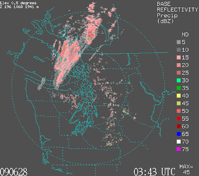
A weak cold front is now moving into western Washington (see satellite and radar) imagery...with increasing clouds and a few light showers on the coast and NW washington. The onshore pressure gradient is rising (currently about 2.5 mb) and that will cause a modest influx of cooler, marine air overnight. So expect a cooling of 5-10F tomorrow and more clouds.
Weather Politics
This week I was in Boulder, Colorado at the National Center for Atmospheric research (NCAR) for the annual WRF model workshop. WRF stands for the Weather Research and Forecasting Model (pronounced WORF--like the security officer on the U.S.S. starship Enterprise). The WRF model is the main high-resolution weather simulation/forecast model used by the research community and most of the local weather predictions you see on the Atmospheric Sciences department web site (and which I show on this blog) are from WRF. It was designed to simulate down to ultra high resolution (e.g., the small turbulence eddies near the surface), but can handle systems thousands of miles across as well. Thousands of researchers and operational centers use WRF...an open, community system. Sounds good so far, right?
Now here is the problem. When WRF was developed in the late 1990's, ghe central idea was that WRF would represent a change in the way in the way numerical weather prediction was done in the U.S. In the the 1970s, 1980s, and 1990s the research community and the National Weather Service were using different computer models. So the insights of the research community were not improving the National Weather Service computer models...which were not as good as they could or should have been. In the mid-1990s...the idea that the NWS and the research community, centered at NCAR, would develop a next generation model and everyone would use it. Research results would flow into operations and students at universities could move to the NWS already experienced with the modeling system. It all started well but during the last few years it has all collapsed. Everyone talks of the divorce. The NWS has essentially decided that it could not use a modeling system developed partially or totally somewhere else and have gone ahead with developing a separate model and modeling system infrastructure. In the meetings this week, it became clear they also wanted to go it alone on their data assimilation system (the software used to analyze all the observations used for weather prediction). There were about 300 people at the meeting, only one was from the National Weather Service. Really sad.
The isolation of the National Weather Service has increasingly resulted in American operational numerical weather prediction falling below the standards of the rest of the world. We are not number one. We used to be number two in global prediction. Now we are maybe fourth or fifth. Don't get me wrong. The local weather forecasters are great and experienced. But they are crippled using models and software tools that are hardly state-of-the-art. And this is driven by an isolated, not-invented-here we don't want it, we know better attitude at the Environmental Model Center (part of the NWS) in Washington DC. The same attitude the delayed the coastal radar for ten years. Perhaps one day, enough people will understand what has happened and demand better, or perhaps our nations congressmen and senators will demand better. I hope so. The U.S. has the best and deepest meteorological research community in the world. We should have the best numerical weather predictions...and we don't. Not even close. With state-of-the-art numerical models and software weather predictions could be much better...saving lives and property. This needs to be changed.
Rabu, 24 Juni 2009
High Lows
An interesting aspect of the weather of the past few weeks, has been the minimum temperatures. Most days have had minima above normal, while the maximum temperatures have gone above and below with relatively equal frequency (see first graphic). The drought is continuing even with the sprinkles of the last day-with June, a relatively dry month average, running about 1 inch below normal (see graphic, red observed, blue normal).
A weak cold front is moving through (see satellite image), followed by increased onshore flow. In this image the front is on the coast. Notice the extensive mountain wave clouds prior to the front, as well as the lee rain/cloud shadowing NE of the Olympics. And the extensive low clouds over the Pacific. The bottom line: cloudy and cooler weather beckons for tomorrow. Conditions improve on Friday and Saturday, with the return of sun and normal temps in the low 70s.
On another topic, someone has set up a twitter account in my name--without my permission. I would like this site to be removed--it was attracting some unfortunate spam yesterday.
Minggu, 21 Juni 2009
Good news and showers
A few positive weather-related developments during the past week:
1. It is looking like we will be able to save the observations taken on Washington State ferries--observations you can view on the Ferry Weather web site (http://i90.atmos.washington.edu/ferry/Ferryjs/mainframe1.htm). WA State Ferries has agreed to pay for the communication service a few more months, which should allow time for the acquisition of hardware for a web-based approach. The funding from the hardware will come from support from the WSDOT grant to the UW. So thanks to WSDOT, this crucial source of weather data over the Sound should be there in the future.
2. More good news. The funding for the weather radar passed the Appropriation Committee of the U.S. House of Representatives. In addition, the NWS site survey team has been actively checking out various potential sites along the coast. We want to watch them carefully...several NWS radars have been placed in terrible locations (like the one in Medford, Oregon!).
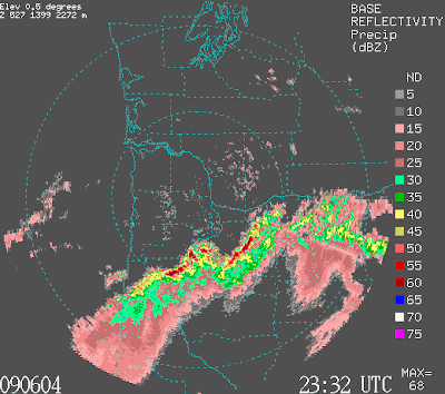
Today was one of instability and showers...with heavy rain and hail in some locations. One shower at my house had huge drops. Look at the latest radar image--some of the radar echoes are impressive. On location had a radar reflectivity values (in dbz) of 63 (the bright red spot in the radar image above--NE of Seattle). This has to be hail. These regional showers are associated with an upper level trough that is making its way across the region today (see image of the heights of the 500 mb pressure surface--roughly at 18,000 ft, a low--heights are low--is right over us. The red is something called absolute vorticity, a measure of the amount of rotation )As the trough moves eastward, we should see a warming and drying trend over the next two days.
Jumat, 19 Juni 2009
Close, but no cigar.
We just missed breaking the dry-spell record by minutes...the official story by the National Weather Service...
.ITS OVER... A SHOWER THAT HIT SEA-TAC AT 0749Z BROUGHT
0.01 INCHES OF PRECIP TO THE AIRPORT BEFORE 08Z ENDING THE DRY
STREAK AT THE AIRPORT AT 29 DAYS. (NOTE: THE DAILY MIDNIGHT TO
MIDNIGHT DATA IS ACTUALLY FROM 1 AM TO 1 AM LOCAL TIME WHEN WE ARE
ON DAYLIGHT SAVINGS TIME ). THE LAST TIME SEA-TAC GOT MEASURABLE
PRECIP WAS BETWEEN 9 AND 10 PM BACK ON MAY 19TH.
(Note: 0800 Z is 1 AM PDT)
Kamis, 18 Juni 2009
No! It Can't End This Way!
If it doesn't rain by midnight we will beat the all time record for consecutive days without rain at Sea Tac during May and June. But, look at the radar image at 8:44 PM...I can't believe it! A band of rain is approaching rapidly! It will take a miracle to save the record now.
So if you know any meteorological incantations...this is the time.
Record Tied
For you record lovers...it didn't rain at SeaTac yesterday (I know there were some sprinkles elsewhere)....so we tied the record. The convergence zone was weaker than forecast last night and we have a very good shot of breaking the record today (longest dry run in May-June).
Eastern Washington and the lower eastern Cascade slopes are very dry for this time of the year. The big worry will be wildfires and ominously we have already had a few burns already. Below is the latest 10-hr fuel moisture map (how much moisture in surface "fuels" that could burn). Eastern Washington is quite dry (but not as bad as the SW). This may be a major issue this summer, so stay tuned.
Selasa, 16 Juni 2009
Will the record fall?
Everyone likes breaking a weather record. Well, we are coming close to beating a "minor league" record...the record number of consecutive dry days in May and June at Sea Tac . The record is 29 days and we are right behind it now with 28. Check out this list of mega-dry periods at Seattle Tacoma Airport.
29 DAYS MAY 28TH - JUNE 25TH 1982
28 DAYS MAY 20TH - JUNE 16TH 2009***
27 DAYS MAY 6TH - JUNE 1ST 1963
24 DAYS APR 30TH - MAY 23RD 1946
23 DAYS MAY 12TH - JUNE 3RD 1995
23 DAYS MAY 30TH - JUNE 21ST 1969
The record number of consecutive dry days ANYTIME of the year at Sea-Tac is 51 days for the period from July 7th through 26 August (1951). So we are not close to that record...which is centered on the driest period of the year (end of July, beginning of August).
Will we beat it? Mother nature is starting to play with us. It is now starting to rain on the coast, but the models suggest that little rain will make it across tonight....but they can be wrong. And all the local models are going for a nice convergence zone late tomorrow/thursday am...so we might tie...but beating the record will be hard! Take a look at the 24-h precipitation ending at 5 PM on Thursday....impressive... with showers in the mountains as well.
Sabtu, 13 Juni 2009
Convection over the Mountains
During the past week it has been completely dry over the western WA lowlands, but not over the crest and eastern slopes of the Cascades, where convection (cumulus, cumulus congestus, and cumulonimbus--thunderstorms) have developed each afternoon. A satellite picture from Friday afternoon shows an example (see image). I have also include radar images from the NWS radar at Camano Island and Spokane. You can see some convective cells over the Cascades and immediately to its east.
So what is going on? During the past several weeks we have had a persistent flow pattern with low pressure to our south and easterly flow (from the east) approaching the Cascades. This air has been only marginally stable, which means it has the potential for convection with sufficient surface heating or mountain lift. Anyway, as this air has started to rise on the eastern Cascade slopes cumulus convection has developed, increasing in strength over the crest. Then as the cells descent the western slopes they tend to weaken...since sinking causes warming and drying that works against convection (see my book for more on this).
There is another way that mountains encourage convection. When slopes are heated, upslope flow often occurs and for a mountain crest upslope flow occurs on both sides. The upward currents join together at the crest with strong upward motion resulting...such upward motion can initiate convection.
Want to see a nice time lapse of convection forming over the Olympics by this mechanism?..check out http://www.drdale.com/lapse/lapse090610.mov
..from a HD cam near Silverdale (Dale Ireland)
Selasa, 09 Juni 2009
El Nino Returns
Some major changes have been occurring in the tropical Pacific. Most of the last winter was characterized by La Nina conditions in which the surface temperatures of the central/eastern tropical Pacific were cooler than normal. But recently there has been a shift to the opposite, El Nino, where the water in that region is warmer than normal. The plot below shows sea surface temperature for several areas in the tropical Pacific..the Nino 3.4 region is the one of most interest. There is a cycle between El Nino and La Nina called ENSO (El Nino Southern Oscillation) that has a period of roughly 3-7 years.
My profession has a variety of ways to predict the future of El Nino and La Nina, the two main ways being dynamical (full physics) and statistical models. The results of these models is shown below (Note that positive is El Nino side). Most models are going for warming (El Nino), although some (mainly the statistical models) are going for a neutral (near zero temperature anomoly from normal)...also called La Nada years.
So why do we care about El Nino and La Nina? Because there is a modest correlation with our weather, particularly during the winter. La Nina years tend to have more cold and snow (like last year!), while El Nino years tend to be drier, with less snow in the lowland and mountains, and weaker storms. I would hesitate to buy an annual ski pass at Snoqualmie Summit if the El Nino strengthens (but don't tell them I said that). And one more thing...during El Nino years southern CA tends to be much wetter than normal.
Minggu, 07 Juni 2009
The Aftermath
The marine push event of last Thursday appears to have resulted in the deaths of three individuals...all of which were on the water that evening. Strong marine pushes generally follow periods of above normal temperatures...which tempt people to get on the water. It is easy to forget how quickly things can change around here.
And lets be honest about the forecast. The official predictions and model forecasts were clear that there was going to be a push, but no one expected it to be as strong as it was. I have studied these events extensively and have published several papers on them and it was only in the hour or two before that I understood how severe it would be (thus my blog entry about "all hell breaking loose." ) The key warning was the increase in the onshore pressure difference early that evening to unprecedented levels. Would it be useful for my profession to create a warning capability based on this pressure difference that was available on the web? Or the NWS could put out a warning on their NOAA weather radio on that basis?
This event has stimulated intense debate in my department. To what degree were the extraordinary winds the result of the unusual onshore pressure gradient and to what degree was the gust front propagating north from the thunderstorms in Oregon important. My gut feeling is the former was key. However, I plan on starting a detailed investigation of this event to really understand its origins.
Finally, a coastal weather radar would have been very useful for understanding what happened. Rain was falling on the southern WA and northern OR coasts and would have allowed the radar to paint out the winds.
Kamis, 04 Juni 2009
A Meteorologically Religous Experience
I just experienced one of the finest weather experiences of my life. I knew a very major push was coming (see my previous post) and headed to the kite hill of Magnuson Park with my wife to experience it. We got to the top of the hill about 8:30 PM, with an extraordinary sunset...the sky aflame in orange and red. I looked to the south wherethe visibility was clearly less...a good sign of an approaching push (see my book for a discussion of this). It was warm up there, with little wind.
And then IT hit. The winds started gusting and a veritable dust storm surrounded us. Some of the dust was from dirt paths, but much of it was pollen and cottenwood debris that had fallen during the past weeks.
The winds increased progressively until there were 25-35 mph gusts. I could hear branches snapping in the nearby woods and my dog became agitated. Looking towards Lake Washington I could see white caps over much of its surface, while far to the north near Kenmore the lake seemed placid. Clouds were moving in aloft with an occasional drop or two. Temperatures had dropped at least 10F in a few minutes. Heading home around 9:15 PM we passed a fire engine approach the park with sirens and lights: someone was probably in trouble.
Arriving home we found a big tree branch downed in our backyard and our plastic patio chairs overturned. My wind chimes are ringing as I write this.
For a meteorologist it doesn't get much better than this!
On the weather radar loop you can see the leading edge of the marine push as a thin line of echo moving NE.
And by the way, did I say that today is my birthday. What a present!
All Hell is About to Break Loose
The funny thing about the weather business is that when things happen, many things happen at once. Today and tonight is such a period.
A powerful marine push is about to happen. Extraordinary onshore pressure differences have developed as the thermal low has shifted into eastern Washington. Look at the attached pressure differences . The difference between North Bend, Oregon (on the central coast) and Seattle is now 7.5 mb and the Hoquiam is now nearly 6 mb higher than Seattle (8 PM). The latter is HUGE. I forecast a major push when that difference is 4 mb, but 6? Strong wind sand cooling temps have already pushed through Hoquiam, Shelton and Olympia and will enter the Sound during the next few hours. Temps will drop, winds will gust, wind chimes will ring, and a comfortable night of sleep beckons. (I REALLY love these pushes, I have to admit)
But that is not all!! A very strong line of thunderstorms hit northern Oregon this afternoon and early evening, with hundreds of lightning strikes, and winds gusting to 40 mph and more. Tens of thousands have lost power, trees are down, lots of heavy rain and hail. Take a look at two radar images (4:32 and and 7:24 PM) the line of thunderstorms is impressive.
Take a look at the latest visible satellite picture...everything imaginable...thunderstorms to our south and east and if you look closely you will see low cloud pushing northward up the Washington coast. I wish I had the coastal radar now...it would be fascinating to see the coastal changes illuminated by the falling rain.
Tomorrow will be much cooler! As they say at the Men's Warehouse-- I guarantee it.
Rabu, 03 Juni 2009
Heat Wave
Yesterday (Tuesday) got to 88F at Seattle and today should be very similar. There is one more day of the hot stuff (tomorrow could hit 90F) and then the marine air will move in for cooler temps on Friday and the weekend.
Lets talk about some subleties of the heat. An essential ingredient is the thermal trough (see sea level pressure forecast at 2 PM). If you look closely you will see a tongue of lower pressure extending into western Washington. Also note the low-level winds..they are from the east. Easterly wind bring warm continental air into the lowlands as well as warming due to sinking along the western Cascade slopes.
The profiler gives winds and temperature above Seattle (see graphic). You see easterly flow aloft and near the surface early in the day. Mid-day,northwesterlies and northerlies come in..that is the Sound breeze, essentially a large region sea breeze. Without the Sound breeze, we would be much warmer...like Portland...so you can look at it as our natural air conditioning. By 9 PM the Sound breeze weakens. That is why you should do your kite flying early in the evening...wait too long and the wind dies.
One of the most interesting things the last few days has been the clouds and rain to our south over Oregon and northern CA. The satellite picture below show the clouds over these regions. The origin? A low center off the California coast that has remained quasi-stationary. An interesting aspect of this pattern is that we have been warmer than much of California (see plot of max temps). The whole pattern should shift late tomorrow...with the thermal trough jumping into eastern WA and marine air starting to move in Friday AM.
Senin, 01 Juni 2009
KCTS and Convection
If you aren't tired of me yet, I will be on KCTS9 tomorrow (Tuesday) at 7 PM. I taped a one-hour weather talk a few weeks ago that will be shown, plus live questions tomorrow night (you can submit them on the web site)....
By the way, there was some nice convection on the Cascades this afternoon....you can see it on the high-resolution satellite imagery and some of it shows on the portland radar (see imagery). There has been lots of convection in Oregon the last few days.
Later this week the convection gets quite close to us...we will see and a marine push is expected late Thursday. Tomorrow should be a notch warmer than today.
Langganan:
Postingan (Atom)