Let me show you an example (see below). Lets go back to April 24th at 8:02 PM (0302 UTC or GMT). The radar is showing little of anything, even though it is in the supersensitive "clear air" mode. A half hour later there is a noticeable increase in the amount of echo (0331 UTC, 8:32 PM PDT), and by 9 PM echoes have really spread and strengthened. This intensification and extension of the radar echoes continued for the next hour.
So did a rainshower move in? Or did a front with rain make landfall? Nope.
The surface observing stations reported dry conditions and generally cloud free skies. It was birds! But why then?
Sunset on that day was 8:12 PM and that is key information. Songbirds like to fly at night (perhaps there are less predators then) and just after sunset they hit the skies for their migration north. And we see this pattern night after night in the spring...and night after night in the fall.
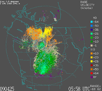
But wait a minute..this is a Doppler radar...we can tell which way they are flying! The Doppler velocity image is shown below for 11 PM. Greens indicate incoming (from the south) and yellows are outgoing (to the north). Thus, with greens south of the radar site (Camano Island) and yellows to the north of the radar, our birds are moving to the north...which makes sense in the spring.
Ornithologists use weather radars for monitoring bird migrations...and now so can you! Imagine when we get a radar on the coast...we will then be able to track the great migrations through Grays Harbor and vicinity. So write or email your Senator and congressman...we need that coastal radar!


Doppler radar below:

Tidak ada komentar:
Posting Komentar